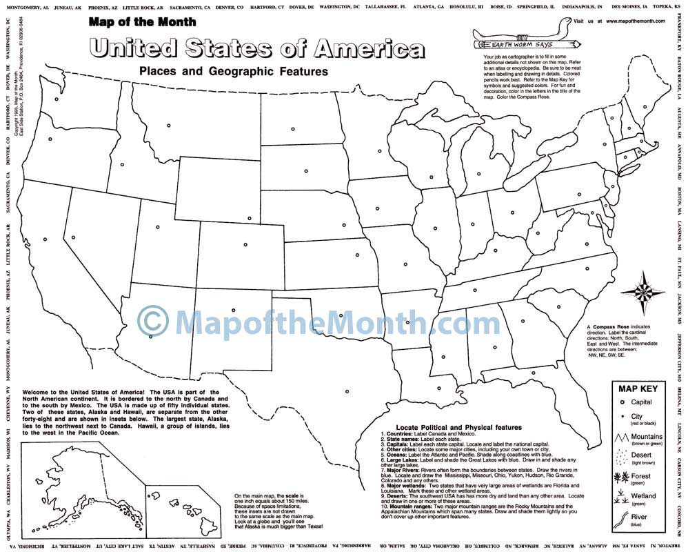
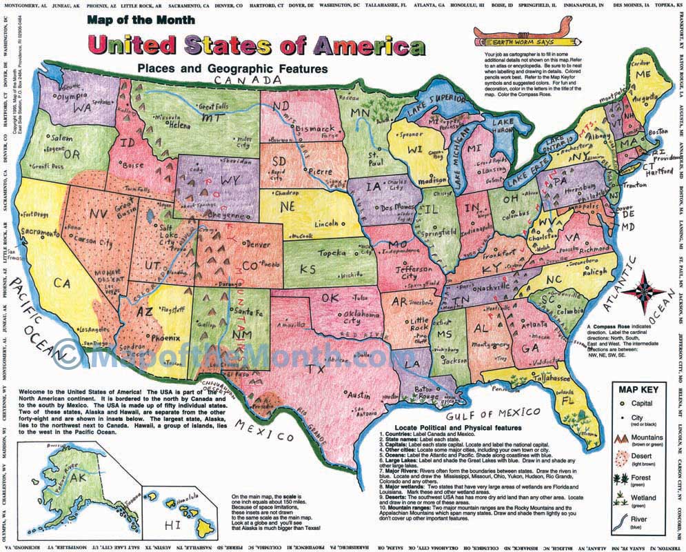
USA, Places and Geographic Features Map
$1.25
- Generously sized – 16 inches x 20 inches
- Outline map – perfect for shading & labeling with colored pencils
- Activities included – use with “on-map” activities or your own lesson plan
Buy Maps in Bulk, Save 20%
| Quantity | Per Item Price |
|---|---|
| 1-300 | $1.25 |
| 301+ | $1.00 |
Why You'll Love the USA Places and Geographic Features Map
Your students can learn state history and geography on our #1 most popular map!
Each map has loads of fun activities for students to gain a deep understanding of US geography, including locating, labeling and shading borders, bodies of water, states, capitals, cities, mountain ranges, deserts, forests, wetlands, and more!
This map has so many creative uses, including a spooky fun idea for Halloween!
Map Features
When you purchase this map you will receive links to download the free bonuses listed below. These are digital files that you can download and begin using immediately.

Bonus #1:
Step-by-Step Mapping - USA Places and Geographic Features
Step-by-Step Mapping is a high-resolution digital file meant for projecting on a whiteboard or viewing on a computer. The activity map is shown in 4-6 stages of completion. A great way to add your own customizations when projecting on a whiteboard!

Bonus #2:
CartoCraze - Mississippi River
You will receive the Mississippi River downloadable workshop (part of our CartoCraze membership.) In this workshop, students explore the river in detail with loads of fun activities, learning resources, and extra printables.
From Blank to Beautiful
Why These Maps Work
A Fun Halloween Project Using This Map
There are so many ways to incorporate our USA map into your curriculum. Here is one really fun idea based on a previous blog post.

Spooky Classroom Mapping
Have your students label the map with cities and towns that have Halloween-related names!
They can learn more about the USA while having Halloween fun! It is fun decorate their special "Spook-City" map with holiday images!
Fun Fact
We learned that the US government does not use apostrophes in place names! So Deadmans Corner is punctuated properly, by the US Board on Geographic names! There are only five places in the USA that still allow the use of an apostrophe. One of them is Martha’s Vineyard – can you find the other four?
Accident, MD
Amityville, NY
Bad Axe, MI
Bat Cave, NC
Black Cat, AR
Blood Hill, NH
Bone Gap, IL
Boos, IL
Casper, WY
Deadmans Corner, ME
Deadman Landing, FL
Dead Woman Crossing, OK
Devils Elbow, CA
Devils Gap, NE
Devils Ladder, ID
Devils Slide, UT
Dies, TX
Frankenstein, MO
Goblintown, VA
Hell, MI
Munster, IN
Pumpkin, TX
Pumpkin Center, FL
Pumpkin Center, SD
Pumpkin Hollow, NY
Pyro, OH
Red Devil, AK
Salem, MA
Satan’s Kingdom, VT
Scary, WV
Screamer, TN
Shivers, MS
Slaughter Beach, DE
Slaughterville, OK
Skull Creek, WY
Spiderweb, SC
Spook City, CO
Spook Hill, MD
Tombstone, AZ
Transylvania Beach, KY
Treat, GA
Trickem, AL
Truth or Consequences, NM
Witch Lake, MI
Worms, NE
You must be logged in to post a review.
What Educators are Saying


Reviews
There are no reviews yet.