Animals All Around Classroom Kit

$100.00

  • A fun way to teach geography to grades 3-6!
  • Everything you need is included!
  • You save $80 over buying maps and bookmarks separately
  • THIS CLASSROOM KIT SHIPS FREE!
SKU: 100125 Category:

Why You'll Love the Animals All Around Classroom Kit

Animals All Around

What makes learning geography even more fun for grades 3-6?

ANIMALS!

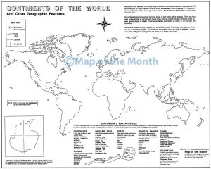
This classroom kit is a fun way for students to learn world geography through the lens of wildlife that inhabit the lands. Using our very popular Continents of the World map, this classroom kit extends the map into a long-term project your students will love!

Our kit contains everything you need - including 11 done-for-you video lessons - making this a fun project that doesn't require a lot of prep time!

You save $80 by purchasing the kit, over purchasing items individually!

What Students Learn

In addition to all the on-map activities included with Continents of the World map, your students will learn:

SCIENCE
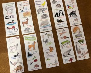
Learn about 45 unique animals from around the world.

READING/RESEARCH
Activities encourage independent study

CARTOGRAPHY/GEOGRAPHY
Students label 45 locations associated with the animals


What You Get

  • 30 Continents of the World activity maps
  • 150 full-color, double-sided animal bookmarks - 5 different sets of 30 featuring all 45 animals. Printed on sturdy, coated cardstock.
  • 45-page downloadable, printable Animals PDF containing loads of interesting information on each animal and where it lives
  • FREE access to our "Animals All Around" 11-video workshop inside of Earthworm University or on YouTube

 FREE Downloadable Bonuses Included with this Map

When you purchase this map you will receive links to download the free bonuses listed below. These are digital files that you can download and begin using immediately.

Bonus #1:
45-Page Animals PDF

This 45-page downloadable and printable Animals PDF contains loads of interesting information on each of the 45 animals, including habitat, predators, and more!

Earthworm University
Bonus #2:
VIDEO: Animals All Around - Discover World Geography Through the Study of 45 Animals 

In this free video geography mini-course series, follow along with our resident cartographer Jason Newton as he completes this map step-by-step. Note: This bonus is not downloadable, but a video tutorial you can access directly inside our Earthworm University or from our YouTube channel.


Already have the Continents of the World map? You can purchase a set of bookmarks and access the free teaching videos inside of Earthworm University!


Reviews

There are no reviews yet.

Be the first to review “Animals All Around Classroom Kit”

You may also like…

What Educators are Saying

profile-pic
profile-pic
profile-pic
profile-pic
profile-pic
profile-pic
profile-pic
profile-pic
profile-pic
profile-pic
profile-pic
profile-pic
profile-pic
profile-pic
profile-pic

Used in Both Elementary and High School

We use many of the Map of the Month maps in both elementary and high schools. They are of excellent quality and are priced right.

Jerry G. - Educator

Students Work Independently or in Pairs

We use the maps in the 5th grade for Social Studies units for review of basic map skills. We also do a unit on the states and their capitals and the provinces in Canada! The students work on the maps independently and sometimes in pairs-- they LOVE them!

Ashley O. - Teacher

Increased Students' Understanding of World Activities

I used your maps for many years before I retired and noticed a definite increase in my students' understanding of world activities based on physical geography. I highly recommend your maps as a learning tool.

Robert P - Teacher

Teach Social Studies Concepts With a Hands-on Approach

Since our school is a Montessori school, we really value geography and cartography. We use Neinhaus maps extensively, and your maps provide a natural extension. Your maps help us teach U.S. social studies concepts with a hands-on component.

Sherri H.

Students Look Forward to the Maps

I have used Map of the Month for about 10 years. Their customer service is outstanding, and they do their best to get the maps to you quickly. The maps are great! The students learn about the world, and there is always something for them to do when they finish their work. So many of my students love the maps and look forward to doing them. I start off with Map Skills, and that sets the expectation for good work. I then do about six other maps through the year. I love these maps!

Nathalie G. - Teacher

I've Been Using the California Maps for the Last 15 Years!

I have been using the California Maps for the last 15 years and LOVE them. I teach California History to fourth graders and using these large maps help the children locate the various areas needed in our studies. My students use these maps as their 'Map Project'. They are given 4 weeks to label and complete all the locations listed on your maps, including the California Missions. The assignment is done at home with atlases as resources: internet as well. Having them search and research on their own, is a skill in itself. The children have loved the project and are very proud of their work upon its completion.

Jensie K. - Teacher

Students are More Prepared for High School

I have used your maps for years in my geography classes and love them. At our combined meetings with our high school, the Social Studies teachers mentioned how much more prepared the students who use them in middle school were. I usually start off with the world map and have them shade the coastlines blue so students can differentiate between the water and land. We "build" our maps together for the first couple with me starting them off and then having them complete several parts for homework. Working on the maps helps students with the concept of being neat, spelling correctly, and following directions.

Val E. - Teacher

Large Maps Give a Better View of the World

I love your maps. I am teaching a K-2 country study this Fall and the maps I bought are for each of the kids to have their own to see where each country is located. Your large map lets them get a better view of the world.

Patricia N. - Teacher

Students Love Working on Their Maps

I really, really like your maps! They look pretty impressive when a whole class worth gets put up on display, the students love working on them and are proud of their accomplishment and the maps are a very effective anchor for lessons in geography, history and vocabulary. They are very cool, plus the staff at Map of the Month is great.

Caroline K. - Teacher

One of the Best Tools I've Used for Geography

My students LOVE this calendar. We use it each morning as one of our morning activities. It is exciting to see them eager to read, research and answer the daily question. With the use of this calendar, I have been able to incorporate geography into daily lessons. The monthly map activities have also proven useful in teaching map skills. This has turned out to be one of the best tools I have ever used to teach geography in my 22 years of teaching.

Meg S. - Teacher

It Allowed Students to Put into Perspective the Miles Traveled

I found using the World Explorer map while studying European Explorers to be extremely useful. It allowed the students to put into perspective the miles traveled and the lengths countries went to to add land to increase their power. I also loved the fact the students were labeling parts of the world they may have never heard of before.

Mackenzie S. - Teacher

I Purchased for International "Talk Like a Pirate Day"

For the past 5 years, I have purchased treasure maps for International Talk Like A Pirate Day and my students have loved them! The treasure maps allowed them the opportunity to use their creativity by designing their own treasure island in full color. Some students distressed their maps by wrinkling them or by rubbing tea on the front to give them an aged effect.

Joseph F. - Teacher

Creative and Fun Ways for Students to Learn About Their State

As an experienced teacher of 18 years, I'm always trying to find creative fun and valuable ways for my students to learn about their state and the world around them while also integrating core curriculum. Map of the Month provided that valuable learning experience through their amazing maps. What a marvelous educational learning tool.

Debra C. - Teacher

We Use the Treasure Map in Conjunction With a Novel

Our third-grade students use the Treasure Map in conjunction with one of the novels they read. After they read the novel, each student creates his/her own treasure map. I had the opportunity to see them this year, and some of them were quite spectacular.

Toni B. - Teacher

I Use the Maps Across the Curriculum, Beyond History and Social Studies

In my classroom, I use the maps across the curriculum as their content extends well beyond History and Social Studies. My students truly enjoy working on their maps. The North American map is an engaging introduction to 5th grade History and Social Studies as is the Early Civilizations map for 6th grade. As corny as this sounds, I find the maps to be of such value to my students that I have personally purchased the maps for the past two years so that they do not miss out on the experience due to budget cuts in our district.

Meredith T. - Teacher
>