May 31
Dellenbaugh, Recording the American West
0 comments
Hands-on geography activity maps kids & teachers
This painting of Zion National Park was made by the American explorer Frederick Samuel Dellenbaugh, who lived from 1853–1935. He was a talented man who had a zest for travel, and the skills of a geographer. He also was an author and a painter.
Dellenbaugh began traveling with expeditions at the young age of seventeen or eighteen. His journeys as a member of expeditions in the West took him to two of the last “undiscovered” places of his time. He and his companions, all amateur explorers, documented the location of the Henry Mountains in Utah. He was part of John Wesley Powell’s second expedition of the Colorado River from 1871-1873.

Dellenbaugh also was present with an expedition that came to the Escalante River, a tributary of the Colorado River which had not been put on record.

This photo of the young explorer shows Dellenbaugh equipped in clothing that suited the rough terrain of his travels. Here he is as a young man of nineteen.

Dellenbaugh’s skills as an artist kept him busy on expeditions: he made maps, recorded information about topography and painted images of place that were difficult to photograph.


In 1884 Dellenbaugh, who loved the American West, lived with the Hopi Indians of the Four Corners area.
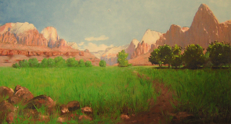
Dellenbaugh was impressed with the canyon we now call ZION NATIONAL PARK. At his first encounter, the area was called Mukuntuweap National Monument. He wrote of his admiration for it in Scribners magazine at the time, and since he was a well-traveled man, we know his impressions were founded on experience:
“One hardly knows just how to think of it. Never before has such a naked mountain of rock entered our minds. Without a shred of disguise it transcendent form rises pre-eminent. There is almost nothing to compare to it. Niagara has the beauty of energy; the Grand Canyon of immensity; the Yellowstone of singularity; the Yosemite of altitude; the ocean of power; this Great Temple of eternity.”
Dellenbaugh spent the summer of 1903 painting Zion Canyon, a place for which he obviously had a great attraction and affinity. His paintings were exhibited in the 1904 St. Louis World’s Fair.

Dellenbaugh was an accomplished author. His book that describes journeys on the Colorado River was published in 1902 and has been reprinted many times.


In 1899, was hired as a landscape painter for the Harriman Expedition, traveling up the coast of Alaska. In later years he also traveled extensively and, as he had always done, kept a daily journal of his travels.

His photos and some of his drawing, paintings, and photos of the expeditions he accompanied can be seen in the Yale University The Beinecke Rare Book & Manuscript Library. He was a cofounder and lifetime member of the Explorers Club, an organization still present in Manhattan, New York City. He served on the board of directors for the Eastern Association on Indian Affairs. His papers include correspondence, a diary of the Powell expedition, manuscripts and drafts of his writings, research notes, sketches, photographs, newspaper clippings: all this and other printed matter can be found in the collections of the New York Public Library.

If you want to encourage your students to learn more about the American West and the people who explored it, rely on our TRAILS WEST map, our THIRTEEN COLONIES map, as well as our ALASKA and individual state maps. All can enlighten your class, with fun activities, about the long expeditions that opened up the land that become our country.
In conjunction with our maps, use our CartoCraze! Expanded Map Workshops for even more detailed DIGITAL material for your smartboard and projector.

Tags
Session expired
Please log in again. The login page will open in a new tab. After logging in you can close it and return to this page.