December 8
SAHARA DESERT
0 comments
Hands-on geography activity maps kids & teachers

Students love learning about the SAHARA DESERT when they are study AFRICA.
Learning about this vast desert expands their ideas of what the world is!
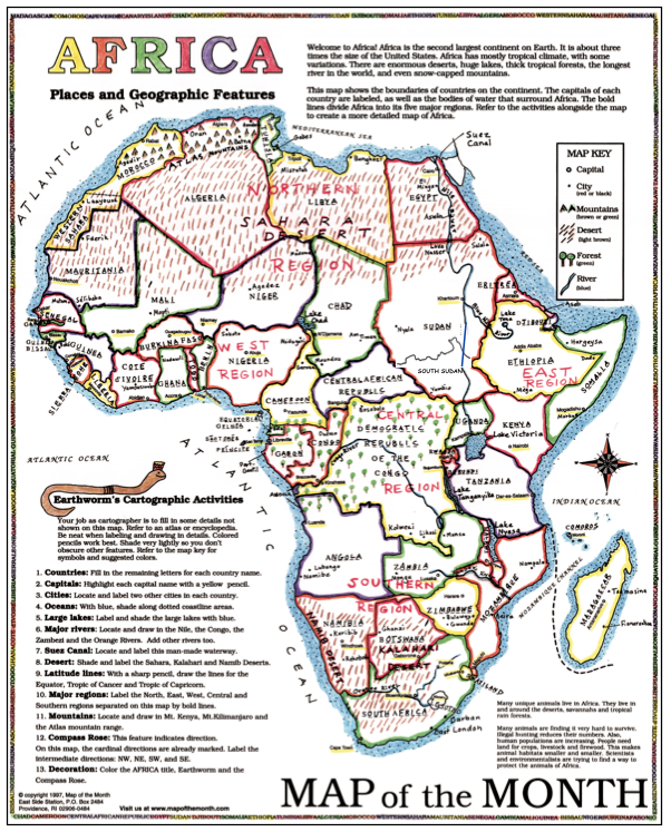
Try out the FREE digital file about the SAHARA in your classroom– click HERE! It is part of our CartoCraze! Expanded Map workshops and adds extra content about the desert and northern Africa. We have 8 different files about the great deserts of the world, and right now, the SAHARA is free for you to use! The files include writing exercises, vocabulary, cultural information, history of the region, and more!
![]()

In addition, the FREE SAHARA file includes:
Desert Terms and definitions
A small map to make
Topography as seen from space!
A feature about the “Rain Shadow Effect” that influences weather and climate in and around the SAHARA.
Old maps of the Sahara from the past.
A feature on the Desert Horned Viper, a creature well-known in the SAHARA.
A feature about sand storms, oases, regional food, and more….
AND– a desert READING LIST!

Antarctic Desert: use with our World, Continents of the World, and Antarctica maps
Great Sandy Desert: use with our Australia map– which also has a FREE digital MAP Challenge file on our site.
Rub Al-Khali Desert: use with our Persian Gulf/Middle East and our ASIA map
Sonoran Desert: provides great extras for all our USA maps and the state maps of ARIZONA and CALIFORNIA
Gobi Desert: use with World maps, CHINA or ASIA map!
Patagonian Desert: wonderful for studying SOUTH AMERICA.
Taklamakan Desert: use with CHINA maps or ASIA maps!


Tags
Session expired
Please log in again. The login page will open in a new tab. After logging in you can close it and return to this page.